7 Best Navigation Apps for iPhones

Streamline your deliveries with Circuit for Teams, enhancing efficiency for every route.
As a delivery professional, you know how crucial GPS navigation is in your day-to-day operations.
You face unique challenges in last-mile delivery. Tight schedules, the necessity for exact drop-off locations, and unexpected changes like road closures and traffic delays are part of your daily routine.
A dependable navigation app is more than a tool — it's your partner on the road.
With your delivery needs in mind, this article will guide you through the best navigation apps available for iPhones.
We'll compare features that matter most for last-mile delivery to help you choose an app that enhances your delivery experience.
Key takeaways
- Navigation apps like Google Maps, Waze, and TomTom GO offer distinct features such as real-time traffic updates, community-driven road information, and advanced lane guidance.
- Apps like Waze and HERE WeGo excel in providing live traffic information and route adjustments, crucial for efficiently navigating dynamic road conditions.
- Apple Maps and Maps.me emphasize offline map accessibility for navigating areas with limited internet connectivity.
- Navigation apps like Sygic GPS Navigation and TomTom GO highlight user-friendly interfaces and customization options, including voice-guided directions and detailed 3D maps, for a tailored navigation experience.
Key features to look for in a GPS navigation app
As a last-mile delivery professional, the right GPS navigation app is a vital tool in your arsenal.
Below are the key features you should look for to create routes that are efficient, safe, and reliable:
- Real-time traffic data. Avoid delays with live traffic updates, helping you reach destinations on time.
- Offline map access. Navigate confidently even in areas without an internet connection.
- Accurate route planning. Optimize travel time and fuel efficiency with precise routing, enhanced by tools like Circuit for Teams.
- Turn-by-turn navigation. Clear, voice-guided directions allow you to focus more on driving and less on the map.
- Automatic rerouting. Quickly adapt to road changes with alternate routes, maintaining your schedule despite unforeseen road events such as traffic jams or road closures.
- Speed limit alerts and speed camera warnings. Stay aware of speed regulations to avoid fines and enhance road safety.
- Integration with other apps. Simplify your workflow with apps that integrate well with other services, particularly last-mile delivery software like Circuit for Teams.
- User-friendly interface. Enjoy straightforward navigation with an intuitive interface, and stay updated with your estimated time of arrival.
- Customization options. Tailor the app to your preferences by saving favorite routes and locations, adding efficiency to your routine.
These features are designed to make your delivery tasks more manageable and efficient, directly addressing the challenges you face daily on the road.
Top 7 navigation apps for iPhones
Selecting the right navigation app for your iPhone is crucial, especially when your work revolves around precise and timely deliveries.
Below are the top nine navigation apps that stand out for their robust features, user-friendly design, and reliability.
Each of these apps is tailored to enhance your delivery experience, giving you the tools needed to navigate your day efficiently.
Apple Maps

Apple Maps, integrated into the iOS ecosystem, offers a comprehensive navigation experience for iPhone users.
Apple Maps' major advantage lies in its seamless integration with the Apple ecosystem, including syncing across devices and compatibility with Apple CarPlay.
Its user-friendly interface, coupled with consistent updates and improvements, makes it a reliable choice for iOS users.
Key features:
- Offline maps. Apple Maps allows you to download maps for offline use, creating navigation continuity in areas with poor or no internet connectivity.
- Real-time traffic updates and traffic alerts. Stay ahead of traffic jams and road closures with up-to-date traffic information.
- Turn-by-turn directions. Offers clear, precise voice-guided navigation, so you can focus on driving without constant screen checks.
- Street view and 3D maps. Gives a detailed street view and immersive 3D map for better orientation and planning.
- Integration with Siri. Use voice commands for hands-free navigation, making your trips safer and more convenient.
- Gas prices and nearby gas stations. Easily find gas stations and updated gas prices along your route, which is particularly useful during long trips or in unfamiliar areas.
Pricing: Apple Maps is free to use for iPhone, iPad, Mac, and Apple Watch users, with no additional subscription or in-app purchases needed.
Google Maps

Google Maps is widely regarded as one of the most robust and detailed navigation apps available for iPhone users.
It's known for its comprehensive coverage, accuracy, and a host of features that cater to a wide range of navigation needs, including those of last-mile delivery professionals.
Key features:
- Comprehensive and accurate mapping. Offers extensive global coverage with detailed and frequently updated maps, which is particularly beneficial for navigating in less familiar or rapidly changing areas.
- Dynamic real-time traffic and incident reports. Gives up-to-the-minute traffic information and alerts about incidents on the road, offering a significant advantage for planning the most efficient routes.
- Intelligent route optimization. The app constantly updates and suggests the best routes based on current traffic conditions, saving valuable time for delivery drivers.
- Multi-mode transportation options. Unlike many other navigation apps, Google Maps has routing for various modes of transport, including driving, public transportation, walking, and cycling, which can be beneficial for planning complex delivery schedules.
- Extensive local business information. Integrates a vast database of local businesses and points of interest, complete with reviews, ratings, and operational hours, useful for locating client addresses and essential services on the go.
- Customizable route planning. Offers the flexibility to add multiple stops, avoid tolls, and prioritize certain types of roads, catering to the specific needs of delivery drivers.
Pricing: Google Maps is available for free without a subscription or in-app purchases.
Waze

Waze is a community-driven navigation app that is particularly popular among iPhone users for its real-time traffic updates and social features.
It gives the most current road information thanks to its large user base actively reporting traffic conditions.
Waze differentiates itself with its real-time, crowdsourced traffic information, which can be more current and specific than traditional GPS apps.
Key features:
- Community-based traffic and incident reports. Waze's primary strength lies in its community-driven updates. Users report traffic incidents, road hazards, and police presence in real time, offering a dynamic and constantly updated navigation experience.
- Smart routing based on real-time conditions. The app constantly recalculates routes based on live traffic data to find the quickest path to your destination.
- Voice-guided navigation. Offers clear, audible turn-by-turn directions, which is crucial for safety and convenience — especially when navigating busy streets.
- Fuel price information. Waze shows current fuel prices at nearby gas stations, helping you find the most cost-effective options on your route.
- Planned drives. You can schedule drives based on expected traffic conditions, an invaluable feature for planning delivery routes in advance.
- Integration with music and podcast apps. Enhances the driving experience by seamlessly connecting with your favorite entertainment apps.
Pricing: Waze is free to download and use, making it an accessible option for all iPhone users.
Sygic GPS Navigation

Sygic GPS Navigation is a robust navigation app for iPhone users with a wide array of features that cater to both everyday and professional navigation needs.
It's known for its offline capabilities and comprehensive feature set.
Key features:
- Offline maps. One of Sygic's standout features is its extensive offline maps. Users can download high-quality maps and access them in areas with limited or no internet connectivity.
- Real-time traffic updates. Sygic gives live traffic updates to help avoid delays and complete timely arrivals. This feature is particularly useful for professionals in time-sensitive delivery roles.
- Voice-guided turn-by-turn directions. Its precise voice navigation allows you to keep your focus on the road, which is crucial for safety and convenience.
- 3D maps and street view. The detailed 3D maps and street view feature gives a realistic view of the surroundings and aids in navigation and location identification.
- Dynamic lane assistant. Helps navigate complex intersections and freeway exits to make sure you're always in the right lane.
- Speed limit warnings. Alerts you about current speed limits and upcoming speed cameras, helping you to drive safely and avoid fines.
Pricing: While Sygic has a basic free version primarily featuring offline maps, the full features are available through the Premium+ subscription.
Priced at $19.99 annually, this subscription can be purchased directly from the App Store for iPhone users.
TomTom GO Navigation

TomTom GO Navigation stands out in the GPS map app market, particularly for iPhone users, with its distinctive features and long-standing reputation in navigation technology.
Key features:
- Advanced offline maps with weekly updates. Unlike many other apps, TomTom GO offers weekly map updates to give the most accurate navigation information even when you’re offline.
- Real-time traffic information with precise ETA. Gives live traffic updates, accurately calculates your estimated time of arrival (ETA), and adjusts routes in real time for delays.
- IQ routes. This unique feature uses historical traffic data to recommend the fastest routes at any given time of the day.
- Premium lane guidance. Offers advanced lane guidance to make sure you're in the correct lane well ahead of junctions or exits, which is particularly useful in complex urban environments.
- 3D visuals. Enhanced 3D visuals for landmarks and buildings, making it easier to navigate in unfamiliar areas.
- Speed camera alerts with updated locations. Regularly updated speed camera locations help you stay within legal limits and avoid penalties.
- Search and navigate with voice commands. Integrates voice command functionality, allowing for hands-free operation and enhanced focus on driving.
Pricing: TomTom GO Navigation offers a seven-day free trial period. You can opt for a monthly plan at $4.99 or an annual plan at $29.99.
Maps.me

Maps.me is a navigation app popular among iPhone users because of its comprehensive offline capabilities. It's designed to be a reliable travel companion, especially in areas with limited internet access.
Key features:
- Extensive offline maps. Maps.me allows users to download detailed maps for offline use, which is ideal for areas with spotty or nonexistent internet coverage.
- Turn-by-turn directions. Offers clear, voice-guided turn-by-turn navigation, making it easier to follow routes without constant screen checks.
- Point of interest (POI) database. Comes with an extensive list of POIs, making it useful for finding everything from gas stations to local attractions, though it may not always have the latest gas price information.
- Bookmarking locations. Users can bookmark specific locations, which is helpful for planning routes and remembering frequent destinations.
- User-contributed data. Maps.me uses data from OpenStreetMap, which is crowdsourced and continually updated by users worldwide, offering a unique and detailed perspective of areas.
- Walking, cycling, and driving routes. Apart from driving directions, the app also gives routes for walking and cycling, broadening its use for different types of journeys.
Pricing: Maps.me is free to download and use, offering all its main features without any subscription or in-app purchase.
HERE WeGo

HERE WeGo is a comprehensive navigation app for iPhone users known for its accurate and detailed mapping.
It offers a blend of features that cater to both casual and professional navigational needs.
HERE WeGo differentiates itself with its extensive public transit information and additional transportation options like bike routes and car sharing.
Its detailed and versatile search functionality allows users to easily find a wide range of places and services. These features make it particularly useful for urban navigators who need a multifaceted approach to travel and route planning.
Key features:
- Turn-by-turn voice navigation. Offers voice-guided directions to promote safe and focused driving without the need to look at your phone constantly.
- Public transit information. Apart from driving directions, HERE WeGo gives detailed information on public transportation options, a feature not commonly found in other navigation apps.
- Bike routes and walking directions. The app also caters to cyclists and pedestrians, offering tailored routes for biking and walking.
- Taxi fare calculator and car sharing information. Unique to HERE WeGo, these features help you compare different transportation options and costs.
- Comprehensive search functionality. Easily find places, businesses, and addresses along with useful information such as operating hours and contact details.
Pricing: HERE WeGo is available for free on the App Store, giving full access to its features without a subscription or additional in-app purchases.
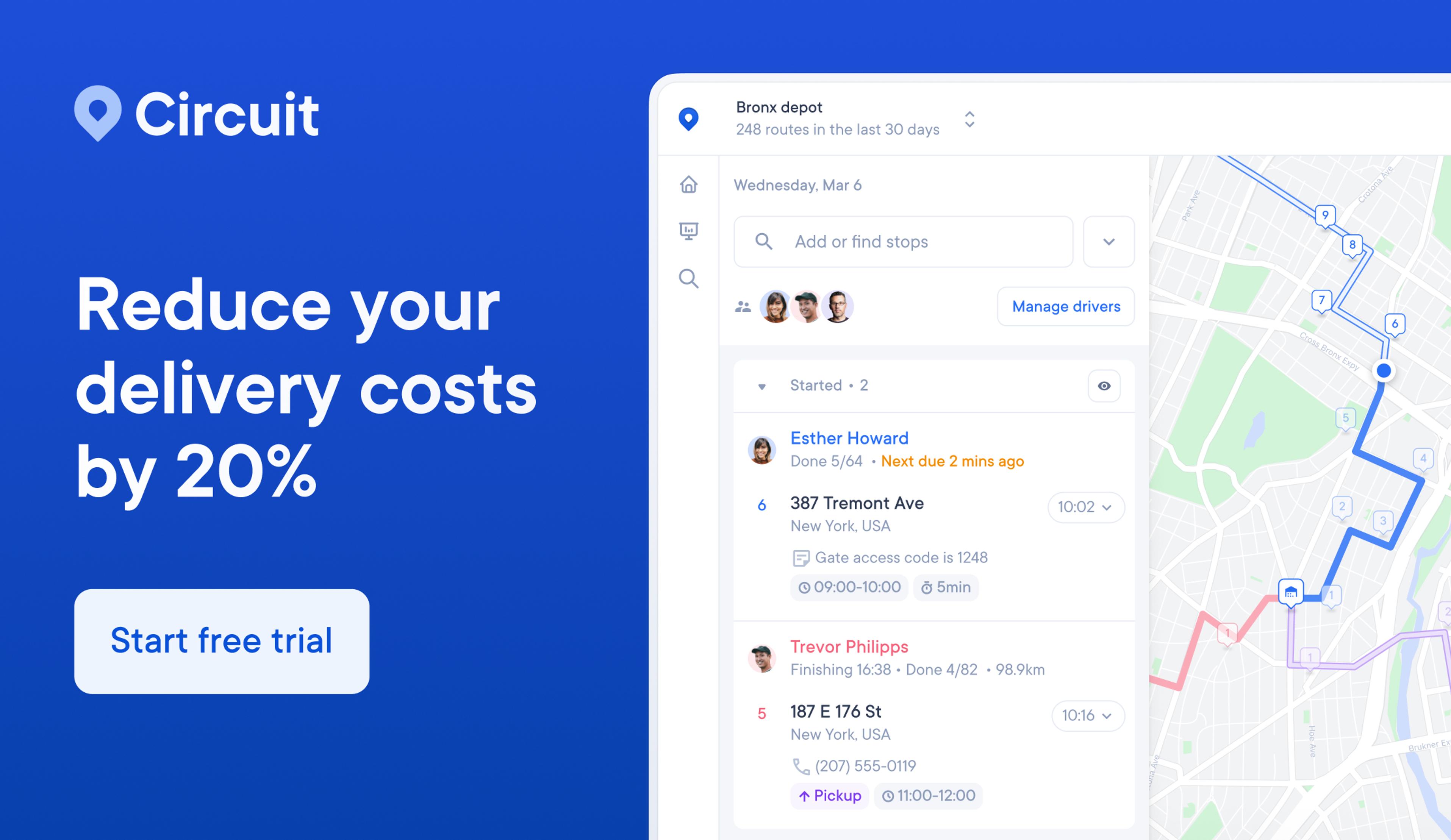
Get more from your navigation app with Circuit for Teams
As we've explored some of the best GPS navigation apps for iPhones, it's clear that each app offers unique features to aid in your journey.
However, to truly maximize your efficiency in last-mile delivery, pairing your chosen GPS app with Circuit for Teams can make a significant difference.
Circuit for Teams is designed to complement your navigation app and streamline your delivery process from start to finish. You can optimize your delivery routes, track your progress in real time, and give accurate ETAs to your customers.
Circuit for Teams has an app for both iPhone and Android, making it accessible no matter what device you use.
Whether you're navigating with Apple Maps, Google Maps, or any other GPS app, Circuit for Teams integrates smoothly to enhance your delivery experience.
Sign up for Circuit for Teams and experience a seamless integration with your GPS navigation app.

